The Chapada is one of the best places in the world to read the evolution of the planet in the landscape itself.
What is the Chapada Diamantina?
The Chapada Diamantina National Park is in the central region of Bahia, between four towns: Andaraí, Lençóis, Mucugê and Palmeiras. Its wider identity region, though, takes in around 24 towns around the Park — possibly more, depending on which geographic aspects you consider.
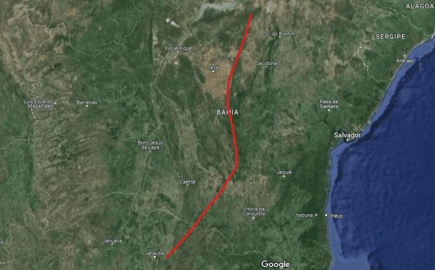
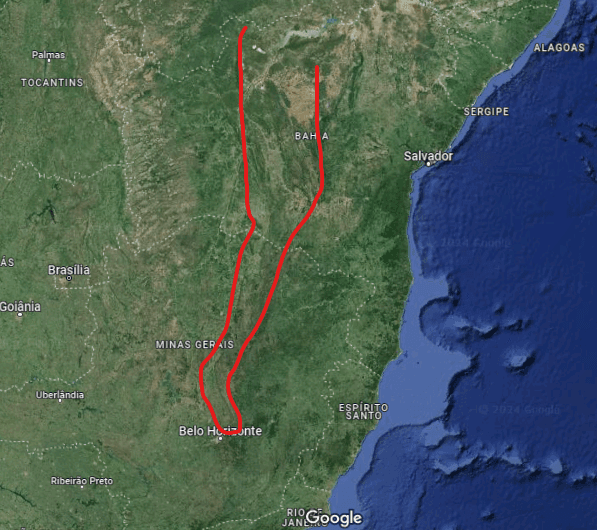
On a map of Bahia you see a kind of ridge, like a column, running north to south. Zoom out and that ridge extends to the central region of Minas Gerais, with a small gap at the border between the states. That formation is the Espinhaço Supergroup, our Brazilian mini mountain range — over 1,000 km long.
It is the result of 4.5 billion years of change in the shape and relief of the Earth. This is one of the best places to observe that evolution, because of the age of the formations and because of the fossils, rock paintings and the whole history that shaped the landscape. Today the region is made of mountains, conglomerates of sedimentary rock and caves.
Northern portion of the Espinhaço Supergroup: the Sincorá Range and the Paraguaçu, Contas and Una river basins.The Espinhaço Supergroup, considered the only mountain range in Brazil.
How was the Chapada Diamantina formed?
About 1.7 billion years ago the region of the Espinhaço Supergroup was a vast basin of roughly 60,000 km² — a large depression resembling a bowl, at the centre of the supercontinent Columbia. Many rivers converged there, and at times the ocean itself came in. Sediments were deposited in that depression over an estimated 700 million years. Only at the end of that process did multicellular life begin to proliferate massively, with the abundance of oxygen in the atmosphere.
The biologist Roy Funch, in A Guide to the Chapada Diamantina, describes the movement as assembling a layered cake that fills the entire basin. During that time the supercontinent breaks apart and comes back together twice more, which leaves the cake misshapen and broken.
Among the collisions of plates and continents, uplift was the geological event that most defined the landscape. Picture two continents colliding: during the impact — which can last millions of years — one portion of land drops and another is raised. It is what happened when India joined Asia, creating the Himalayas; in our case, when America joined the African continent.
After that, erosion did its work of opening valleys, caves and gorges, redrawing the landscape into what we know today. Water slowly penetrates between the rocks and extracts small sediments, which will flow into rivers and oceans and form the mountains of the future, millions of years from now, when the continents collide again.
Limestone and Salitre rocks
Mainly between Irecê and Iraquara, and also to the south, near Andaraí and Nova Redenção, around the course of the Una River — a tributary of the Paraguaçu. Potentially the last group to form. They draw attention for the number of caves and grottos, and there are reports of fossils inside the Poço Azul.
Sandstone conglomerates
The oldest formations in the Chapada. Sedimentary rocks of various types and origins which, after the uplift, formed plateaus, valleys and mountains. Found throughout the National Park and its surroundings — the most common of all.
Where to see the main formations?
Our main suggestion is the Muritiba Park. Beyond the great massive sandstone conglomerates at the Serrano Natural Pools, you can see weathering in the rocks of the Salão de Areias Coloridas, which crumble at the touch, and the very rare igneous rocks of the Poço Halley, the result of volcanic activity in the area.
On the way to the Sossego Waterfall there are geological folds that show the force of the impact that uplifted the Chapada, plus the endless sedimentary layers that make for a rugged, singular landscape. The grandeur of the Pati Valley, at the heart of the National Park, is also worth seeing.